Case Study: Map-Based Location Intelligence App | DignityMoves
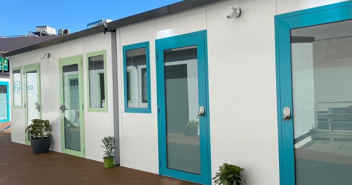
Problem: DignityMoves needs to quickly and efficiently understand precisely where they can build interim housing to help reduce or even eliminate homelessness. They had to drive around cities, looking for potential property, finding out who owned it, then calling to see if a deal was possible. This took an enormous amount of time, often to simply find out the answer was “no.”
Solution: LandVision® gave DignityMoves the ability to locate and analyze prospective property opportunities quickly.
Benefit: DignityMoves can now quickly identify which sites will work and which won’t. This means they can devote more time to building interim housing that will help the homeless.
TIME IS OF THE ESSENCE FOR AN ORGANIZATION LIKE DIGNITYMOVES, AND LANDVISION® WAS THEIR KEY TO MOVING QUICKLY AND EFFECTIVELY.
DignityMoves is a non-profit organization that believes every community deserves interim supportive housing for the homeless that is fast, cost-effective, and scalable while at the same time developing a supportive community and delivering the services they need.
LightBox spoke with Joanne Price, Vice President of Strategic Initiatives and Holly Million, Vice President of Advancement, about how DignityMoves uses LandVision from LightBox and what it’s done for their organization.
What is DignityMoves trying to accomplish?
The homelessness problem is persistent, and there is very little real movement in solving the issue. We feel we’re bringing a fresh perspective to the problem by building affordable interim supportive housing to help get people off the streets.
What makes us different is that we’ve found a way to build cost-effective, modular, individual private units where formerly unhoused people have the dignity of privacy, be able to lock their doors, have a place to store their possessions, and, best of all, an address. It’s a way of giving them the stability to help put their lives together.
What are the obstacles you’re facing?
We work with governments, so there are often a lot of burdensome regulations and processes to comply with. But we’ve discovered ways to get around that by essentially renting the land for our purposes. Sometimes the land is donated, but most often, it is property that isn’t currently being developed, that’s just fallow and unused.
But the most significant obstacle is the enormous amount of time it takes to find the land in the first place. Initially, we would have to drive around, looking for a property we thought we could use, then spend time figuring out who owned it, attempting to contact them, and most often discover that the answer was “no.”
Our mission has begun in California, where multiple laws dictate where we could build and need to accommodate the California Environmental Quality Act (CEQUA).
We must move quickly because the homeless problem isn’t improving. We needed a way to discover where usable land was and secure it.
How has LandVision helped you?
LandVision was, frankly, a saving grace. It helps us identify land that appears suitable for our needs and quickly find out who owns it and whether or not we could strike a deal for us to build on it. It reduces the 10-20 steps we needed to take to one.
LandVision has essentially been “Google for Land” for us. It helps us identify critical information, such as locating flood plains or knowing where bus lines or schools are. LandVision is a wealth of knowledge, especially from one piece of software.
LightBox will be adding a Zoning Location function to LandVision. Will that be helpful?
Absolutely. Knowing that the land we’re looking at is zoned as a “by right” area automatically lets us bypass the CEQUA approval process—saving us an incredible amount of time. So, yes. Zoning information is very important.
What would you say is the single most important thing LandVision does to help the DignityMoves mission?
It saves us time in correctly qualifying usable sites. We should also say that the time it keeps us away from disqualifying sites is also crucial.
Homelessness is a national issue, not simply one to solve in California. DignityMoves believes our model can work nationally, and LandVision is a primary tool for making that happen.
This Week’s Sponsor
LightBox is the world’s leading real estate information and technology platform. Through operational excellence and a passion for innovation, the company facilitates transparency, efficiency, insight, and prediction for real estate investment and location analytics.
Read Next
 5/29/2025
AI Can’t Fix Bad Data. These Ideas Can Get You on the Right Track. Real estate visionaries constantly integrate innovative technology to make their organizations more efficient.
 5/22/2025
Managing Building Automation and Integration Like an Investment Portfolio What if your building automation and integration decisions were managed with the same precision, discipline, and long-term vision as Warren Buffett’s investment portfolio?
 5/15/2025
Tech, Talent and Transformation: 2025 Digie Finalists Announced For 27 years, Realcomm has presented the Digie Awards to acknowledge companies, real estate projects, technologies, and individuals that have advanced the commercial real estate industry through the strategic use of technology, automation, and innovation.
 5/15/2025
Empowering Space Management with Data-Driven Visualization For effective CRE space management, it’s critical to centralize lease data, maximize rental square footage (RSF), improve energy efficiency and reconfigure spaces to meet changing needs.


%20(1)%20(1)%20(1).png)


